 |
|
|||||||||||||
|
|
||||||||||||||
|
|
 |
|||||||||||||
|
|
||||||||||||||
|
|
||||||||||||||
|
|
||||||||||||||
|
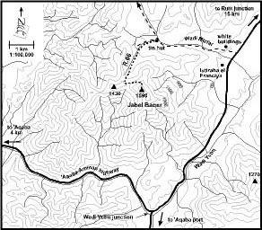
1.
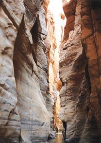
Wadi Mujibs lower gorge The view which the Mujib represents is very striking the valley looks like a deep chasm formed by some convulsion of the earth, into which there seems no possibility of descending to the bottom. (J. L. Burckhardt, 1812)
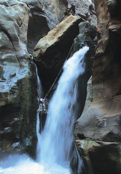
Wadi Mujib's waterfall (Itai Haviv) Experiencing
Jordans Grand Canyon involves swimming, jumping, abseiling and floating.
Seen from its bottom, its sheer red walls tower skyward while its all
width is filled with running water, plunging through an awe-inspiring
15 m waterfall.
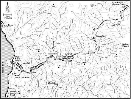
Ascend along the right side of the little wadi, following a ruined track to reach a T junction after about 20 minutes. Turn left, descending past the campsite of the reserve before climbing steeply once again. It takes about 50 minutes to reach the top of the ascent. Before you descend into Wadi Mujib, climb to one of the light-colored marl mounds for a comprehensive vista. The Dead Sea expands below with the escarpment of the Judean Desert rising above its opposite shore. At the foot of the escarpment lies the settlement of Ein Gedi, famous as an oasis and a subtropical nature reserve. Looking east, it is easy to spot the course of Wadi Mujib but it is almost impossible to locate its outlet. A closer look reveals that the most natural outlet is through the valley from which you ascended. The valley, however, seems to be blocked with light colored marl layers, which were deposited at the bottom of the Dead Sea at a period when its level was much higher. During the last Ice Age the water level of the Dead Sea reached 180 m below sea level, about 230 m higher than today. The lake flooded the lower reaches of the canyons along its banks, which became bays and begun to accumulate sediments. As the climatic conditions changed, about 20,000 years ago, the water level of the lake dropped, leaving the re-emergent canyons blocked with lake marl. Most canyons managed to cut through their plugged outlets and to resume their erstwhile lower courses. However, Wadi Mujib abandoned its former outlet by breaking through a cleft in the sandstone. This narrow cleft became the bottleneck of an enormously large drainage basin with a huge discharge. During the years the cleft was scoured deeper and the gorge of Wadi Mujib was formed. Leaving the lookout point, descend along the track to reach the wadi bed within 20 minutes. The impressive gate of the Mujib gorge can be seen to the left, but before venturing into the gorge proceed upstream for 30 minutes towards the confluence of Wadi Mujib and Wadi el Hidan. Walking in the water among reeds and oleanders, turn left at the confluence. Advance along boulders on the left-hand side of the wadi, arriving soon at a beautiful pool. Just above the pool is a rocky platform, convenient as a base for further exploration. Beyond the pool begins the majestic gorge of Wadi el Hidan. Its smooth sandstone walls curve upwards while sparkling water fills its whole width. Leaving your gear behind, you can swim into the gorge and even cross a few cascades before a gushing low waterfall blocks your way. It is a magical place.
Wadi Mujib's lower gorge (Shai Reuveni) Retrace your steps downstream to reach the entrance to the lower gorge of Wadi Mujib. Put valuables in a waterproof bag before progressing. Water level in the gorge may be waist-high and there are sections where you have to swim. Descending the Mujib gorge is an awe-inspiring experience. Its sheer walls are so close and so high that the sky is seen as a mere blue ribbon between the red rims. Bypassing a pile of boulders from the right, you reach the breathtaking Mujib waterfall about 40 minutes from the head of the gorge. Its gushing waters drop 15 m into a pool surrounded by vertical walls. The only way down is by abseiling. Once beneath the waterfall, a demanding section is still ahead. Stick to the right side of the gorge, descending a vertical drop using a short rope. Soon afterwards, return to the middle of the gorge and slide down a smooth boulder. Another giant boulder lies just ahead. Hold on to a rope and slide to the edge of the boulder towards a 2 m drop into a shallow pool. A turbulent pool is a few minutes ahead - take care! The final section towards the outlet is a peaceful journey with no serious obstacles. The Mujib Bridge is reached some 90 minutes from the waterfall.
The Mujib Nature Reserve
2. Jabel Baqer "Nothing could be more beautiful than the Gulf of 'Aqaba, gleaming through its fringe of palm-trees, as we left the fort, like a placid lake - an eye, rather, of the deepest blue, eye-lashed with palms, and eye-lidded with the Arabian mountains." (Lord Lindsay, 1837)
Acacia tree For magnificent views over the Gulf of 'Aqaba and the 'Araba Valley, no other peak in the area can compete with Jabel Baqer. Towering to 1590 m, this lofty granite mountain overlooks Jordan, Egypt, Saudi Arabia and Israel. Just be there!
Leaving the tin hut climb south along a side wadi, which leads towards the obvious saddle of Jabel Baqer. Within about 30 minutes, a cluster of palm trees is seen to the left. Above the palms is a deserted agricultural terrace, where pomegranate and grapevine were once cultivated. Another 40 minutes will take you to the saddle (1,280 m), from where you see the railroad to 'Aqaba winding through Wadi Yutm. The pile of stones is probably a ruined leopard trap.
Jabel Baqer |
||||||||||||||