 |
|
|||||||||||||||||
|
|
||||||||||||||||||
|
|
 |
|||||||||||||||||
|
|
||||||||||||||||||
|
|
||||||||||||||||||
|
|
||||||||||||||||||
|
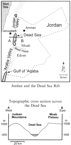
Geography The Dead Sea Rift is an elongate depression, stretching along more than 1,000 km from northern Syria to the Red Sea in the south. The Jordanian section along this depression includes the Gulf of 'Aqaba, the 'Araba Valley, the Dead Sea and the Jordan Valley. The eastern boundary of the Hashemite Kingdom of Jordan runs along the centerline of the Rift.
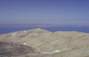
The
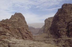
Dead Sea viewed from the The Gulf of 'Aqaba is part of the Red Sea, which is a northern extension of the Indian Ocean. Between the Gulf of 'Aqaba and the Dead Sea stretches the 'Araba Valley, divided by a rather indistinct mid-valley watershed into a northern section, which drains toward the Dead Sea, and a southern section, which consists largely of mud flats and salinas. The lowest part of the Rift is the Dead Sea, whose present shores lie at 410 m below sea level. The Rift's flank east of the 'Araba Valley and the Dead Sea forms a steep slope whose peaks reach 800-1,700 m above sea level. These peaks constitute the edge of a wide plateau, which slopes gently eastward, towards the interior of Jordan. West of the Dead Sea and the 'Araba Valley, the western flank of the Rift rises to 500-1,000 m forming the Judean Mountains and the Negev ranges. The great difference in altitude between the bottom of the Rift and the plateau to the east is responsible for a rugged terrain incised by numerous deep canyons. Many of the canyons carry year-round streams forming a sharp contrast to the arid environment.
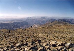
Two geographical regions can be distinguished in Jordan between the northern part of the Dead Sea and the Gulf of 'Aqaba. The northern region corresponds to biblical Moab and the southern to biblical Edom. The transition between these two regions is marked by Wadi Hasa, which was the border between the kingdoms of Moab and Edom (12-6th centuries BCE). The highest peaks of Moab rise to 1,300 m, while those of Edom reach 1,700 m. The plateau of Moab was noted for its wheat and barley fields, whereas Edom was more of a pastureland. Today, the municipal districts of southern Jordan are no longer called Moab and Edom. The region of Moab includes the districts of Amman and Karak and the region of Edom includes of the districts of Tafila and Ma'an. The major cities in Moab today are Karak and Madaba, while those in Edom are Tafila, Wadi Musa, Ma'an, and 'Aqaba.
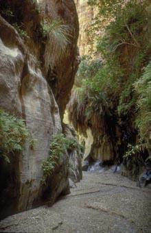
Hanging
gardens in the canyon The topography of the Rift dictates a steep east-west climatic gradient. Clouds, which form over the Mediterranean Sea, are blown by prevailing westerlies towards the Judean mountain ridge. As they move over the rising land, they cool and eventually precipitate, dropping most of their load over the ridge of Jerusalem, Bethlehem and Hebron (450-700 mm). Moving further eastwards, the clouds descend towards the bottom of the Rift, warm up and hardly yield a drop of rain (20-90 mm per year). When the eastwards drifting clouds are driven up the edge of the Jordanian plateau, they precipitate once more (300-500 mm in the vicinity of Madaba and Karak) before fading away over the desert to the east. Due to the north-to-south regional aridity gradient most of Edom receives less rainfall than Moab. This pattern of rainfall leaves Jordan with an arid desert covering more than three-quarters of the country. Only a narrow stretch along the peaks of the plateau receives adequate amount of seasonal rainfall. Consequently, there are very few permanent settlements along the Dead Sea and the 'Araba, and none along the steep slopes of the Rift. The climate of Jordan is a mixture of desert and Mediterranean climates. Winter is cold and rainy and summer is hot and dry. However, the east-west climatic gradient makes it possible to enjoy comfortable weather conditions in the bottom of the Rift during the winter as well as in the elevated areas during midsummer. Three main roads run the length of Jordan from north to south. The lowest road runs along the Dead Sea shore and the 'Araba Valley. High up, on the upper reaches of the steep slope, lies the historic King's Highway. Transverse roads and tracks connecting these two meridional routes are few, and their grades are very steep. On the plateau to the east is the Desert Highway - the fastest way to travel the length of Jordan. Exploration of the Jordanian Dead Sea Rift During most of the Ottoman period, anarchy prevailed throughout Jordan and Palestine, and security conditions were very poor. It was only in beginning of the 19th century that a few daring explorers first ventured into the wild region east of the Jordan River and the Dead Sea, motivated by the will to discover the lands of the Bible. The charm of the Orient, as well as the spirit of adventure, soon attracted many travellers, researchers and artists. Though they carried arms and had Bedouin escorts they still faced tremendous difficulties.
Ulrich Jasper Seetzen, 1806-1807 The German doctor Seetzen was the first known western explorer to travel through Jordan since the Crusaders. He travelled under the name Musa el Hakim, spoke fluent Arabic and was a convert to Islam. His first journey through Jordan took him along the King's Highway to Karak and then down to the Dead Sea shore. He crossed the outlet of Wadi Hasa and skirted the southern tip of the Dead Sea. On a later journey, Seetzen walked along the entire eastern shore of the Dead Sea! He insisted on following the lake's shoreline even where his Bedouin guides declared it to be impossible.
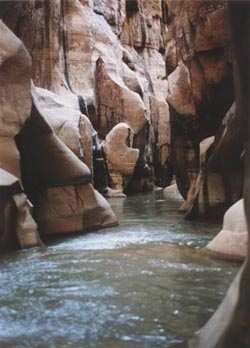
The gorge of Wadi el Hidan (Shai Reuveni) More than 40 years after Seetzen the traveller De Saulcy (1851) wrote about the difficulties of walking along the Dead Sea shore:
Seetzen is the first to describe Wadi Mujib's lower gorge. Among his many discoveries were the warm springs of Wadi Zarqa Ma'in, Callirhoe (Hammam ez-Zara') and the fortress of Machaerus. Although he travelled through unknown land he did not stick to main routes. It was many years before others walked along paths that he had trod. Seetzen was murdered in Yemen in 1811.
John Louis Burckhardt, 1812 The Swiss traveller Burckhardt is renown for discovering Petra to the western world. Disguised as a Muslim who had vowed to sacrifice a goat at the tomb of Aaron, he ventured into the ancient city and published a detailed description of the site. Burckhardt was the first to travel through Edom. After his visit to Petra it became the dream of many travellers.
L. E. Laborde, 1828 A French explorer who travelled through Edom and Sinai disguised as a Bedouin. Unlike Burckhardt he travelled in style with a caravan of sixteen camels. Laborde was the first to approach Petra from 'Aqaba through the southern part of the 'Araba Valley. On his return journey from Petra to 'Aqaba, he visited Wadi Sabra and the Nabataean site Humeima. Laborde was later appointed director of the Louvre Museum in Paris. His sketches of Petra illustrated the region for many scholars and armchair travellers.
Wadi Tajra and the cliff of Umm Ala (Itai Haviv) Lord Lindsay, G. H. Von Schubert, G. H. Moore and W. G. Beke 1837 The Englishman Lindsay and the German Von Schubert travelled shortly after each other through the whole length of the 'Araba Valley. Schubert was among the first to realize that the Dead Sea and parts of the 'Araba Valley were much lower than global sea level. At about the same time, Moore and Beke reached the same conclusion. The discovery was a scientific sensation.
D. Roberts, 1839 The artist David Roberts is renown for his paintings of Petra as well as of many other historic sites in the region. His work reached a much wider public than the accounts of his predecessors.
W. F. Lynch, 1848 Captain Lynch headed an official exploration party of the American Navy, which negotiated the length of the Jordan River from the Sea of Galilee to the Dead Sea. The Lynch expedition produced an accurate map of the Dead Sea with many of its adjoining canyons.
During the second half of the 19th century many travellers and researchers visited Moab and Edom. These included the English clergyman and naturalist H. B. Tristram and the Czech explorer Alois Musil. The most explored route was along the King's Highway, though some travellers also visited the Dead Sea and the 'Araba Valley. Thus, we have descriptions of the upper reaches and the outlets of many canyons that flow into the Rift Valley. However, the long, jagged belt between the King's Highway and the bottom of the Rift remained only lightly explored. Transverse routes from east to west were few, steep and dangerous. Obviously, walking through flowing canyons, which were impassable to pack animals, was out of the question. Moreover, since the main motivation for explorations was identifying biblical sites, the canyons and the rugged peaks hardly drew any attention. For the last fifty years the access to the 'Araba Valley and the Dead Sea was limited due to their proximity to the border with Israel. There was even no tarred road along the northeastern shore of the Dead Sea until the early 90's. The 1994 peace agreement with Israel made the Rift Valley considerably more accessible. Nevertheless, even today there remains much which is still unexplored. |
||||||||||||||||||